

Your summer holiday in the kingdom of the Hochkönig
mountain meadows, pleasurable moments hiking, climbing or mountain biking...
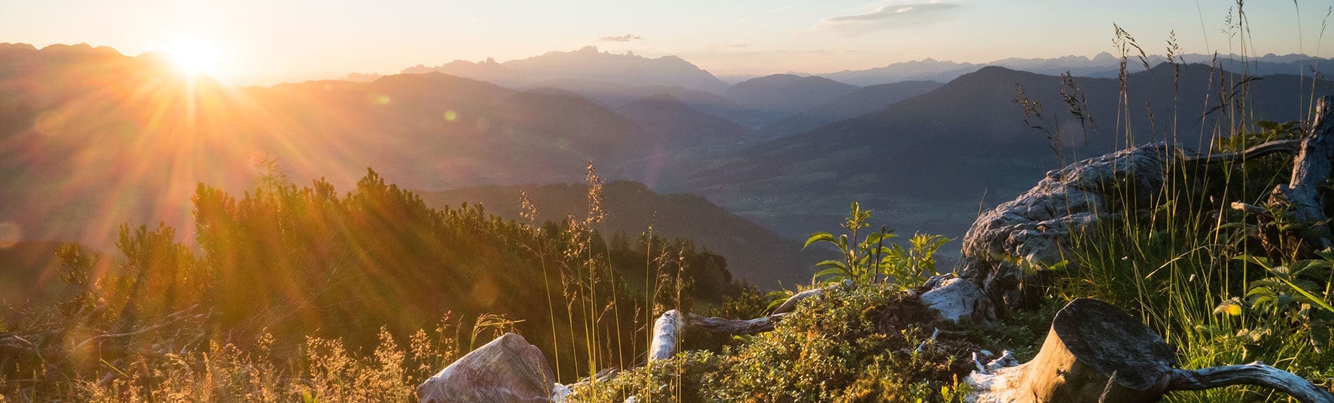
Legendary and imposing: the Hochkönig, with its 2,943 m counts as one of the most majestic mountain ranges in the Alps. High up on its rocks you'll find a real paradise for mountain sports, at its feet a fascinating alpine meadow landscape. Here, at an altitude of 1,307 m, the Alpengasthof Kopphütte makes the perfect starting point for hikes and mountain tours of all levels of difficulty. Undertake a short walk through the forest to the Mühlbach Mountain Museum and enter into the world of the Hochkönig Miners (approx. 60 minute walk away from the Kopphütte). Bikers can jump onto their mountain bikes or e-bikes and enjoy the gravel beneath their tyres, the views from high up and much, much more. No matter whether you wish to conquer the Hochkönig or prefer to observe the mountains from the valley below - your summer holiday in Mühlbach in Salzburger Land is sure to be unforgettable!
Hiking & mountain climbing
genuine peak conquests & culinary rewards
- Kopphütte lies at the heart of the Hochkönig hiking area, the perfect starting point for tours to suit all ability levels
- Hiking & mountain tour pleasure along the 340 km long, well-signposted network of routes in Mühlbach, Dienten & Maria Alm
- Mountain & climbing tours in the Hochkönig range: high alpine routes, climbing trails (e.g. the famous Königsjodler - King's Yodeller), exposed summit tours
- Long-distance trail Königsweg (King's Path): 74 km long, 4,842 m elevation gain & 4 stages
- Other long-distance trails through the region: Salzburger Almenweg & Via Alpina
- Themed trails: Mitterberg-Erzweg, Forest Adventure Trail, Nature Trail Bockluftweg, Pilgrimage Trail, Herb Path (along 16 herb alms, guided herb walks with qualified herbalists)
- Resorts & Königsweg awarded the Austrian Hiking Seal of Approval
- Stop for refreshment & enjoy: a total of 71 alpine huts in Mühlbach, Maria Alm & Dienten
- High alpine tours & climbing tours with professional guides bookable at the local sports schools
- Wanderbus (hiking bus): free travel with the Hochkönig Card
- Comfortable hiking using the summer lifts: Karbachalm Cable Car, Bürglalm Chairlift, Gabühel Cable Car, Hochmais Chairlift, Schwarzeckalm Chairlift, Natrun Cable Car – free travel with the Hochkönig Card
- The hotel owner Bernhard, a qualified hiking guide, is on hand for tips & advice regardig route planning
Kopphütte – waterfalls – "Four Huts" – Kopphütte
- Walking time: approx. 1 hr. 35 mins.
- 4.5 km · 240 m elevation gain, uphill & downhill
The beautiful path into the Riedingtal Valley is not steep and is also suitable for children. Enjoy the splendid panoramic views from one of the rustic benches along the way. After 40 minutes you catch sight of the waterfalls (1.8 km/100 m elevation gain). Depending on the weather conditions up to five streams gush out of the Gamskar'l into the depths and join up in the Schrambach, which entices you to a refreshing dip and to build dams.
Thereafter it gets a bit steeper. The path leads over the former training jump for the ski jumper Sepp Bradl to the scenic "Four Huts". Here you'll also need around 20 minutes (1 km/150 m elevation gain). From here on it's downhill, past the "Two Huts", back to the Kopphütte (35 mins./1.8 km/200 m elevation gain).

Hochkeil Circular Trail
- Walking time: approx. 2 hrs. 45 mins.
- 8.5 km · 190 m elevation gain uphill, 450 m downhill
Starting point for the panoramic Hochkeil circular trail is the Arthurhaus. First of all head at the foot of the Mandlwände along the marmot trail towards Bischofshofen, before you come to the protected Troiboden high alpine moor. The wide forest track leads onward, mostly downhill, through scenic forest interspersed with large clearings. Past the Kalte Bründl stream, enticing you for a refreshing dip, you come to the southern side of the Hochkeil.
Before you reach the Mandlwand road beneath the Saukar car park, you get a fantastic view of the majestic Hochkönig and the Bratschenköpfe. Now you can either take the Wanderbus or walk along the Erzweg (approx. 2 km) back to the starting point or along our access road back to the Kopphütte (approx. 2 km). This circular tour is also suitable for pushchairs.

Kopphütte – Erichhütte – (Taghaube)
- Walking time in one direction to the Erichhütte: approx. 1 hr. 50 mins. (6.5 km/200 m elevation gain uphill)
- Walking time Erichhütte – Taghaube – Erichhütte: approx. 2 hrs. uphill, approx. 1 hr. 20 mins. downhill (1.5 km/600 m elevation gain)
The scenic high alpine trail at the foot of the Hochkönig range is a "must" during a stay in our region. At first the trail leads along a gravel road to the Wiedersbergalms (approx. 200 m elevation gain), whereby the biggest ascent is accomplished. Now a narrow high alpine trail leads off to the left of the "Four Huts" over lush alpine meadows to the lower Birkar, where the Trockenbach stream entices you to build "stone men". Heading on towards the Dientner Sattel a path leads through wide mountain pine fields to the Erichhütte.
The Taghaube offers those with a head for heights the possibility to savour high alpine air. Above the Erichhütte the trail leads at first over alpine pasture to the "Kuhbalfen". Then you head off to the right at first through mountain pine then scree fields up to the rocks. From here on you need to make use of your hands, in order to reach the summit safely. A number of wayside shrines serve as reminders not to get over enthusiastic and distracted. Arriving at the summit you get a fabulous view of the Salzburg mountains. The descent is along the same way back to the Erichhütte.
Back to the Kopphütte you can either head along the high alpine path past the Wiedersberg or to the Dientner Sattel (approx. 1.5 km and 200 m downhill) and return on the Wanderbus. (To save 30 mins. journey time, we recommend you use the "Trockenbach" bus stop and walk back along the picturesque trail (No. 88) between "Trockenbach" and "Elmaubauern" back to the Kopphütte (approx. 1.5 km 150 m downhill). Make sure to take plenty to drink with you, as there are hardly any springs offering drinking water along the way and the air in the mountain pine fields can be very hot.
For those wishing to conquer the Hochkönig, this tour (there and back) serves as an initial test to see whether your physical condition is up to standard. Those not wishing to stick to bus timetables can of course take the bus to the Dientner Sattel and then walk back along the high alpine trail.

Kopphütte – Rohrmoosried'l – Viererwasch – Kopphütte
- Walking time: approx. 1 hr. 30 mins.
- Approx. 6 km · 250 m elevation gain up and downhill
Starting at the Kopphütte the path at first leads along the toboggan run (open in winter) towards Mühlbach through the tranquil mixed Rohrmoosriedl forest until you come to the power plant water reservoir. There you can observe trout and other water inhabitants.
The trail then leads onward without any notable incline to the so-called "Viererwasch". Here, at the time of the heyday of copper mining in Mühlbach, Mitterberg ore was washed for the fourth time, before it was transported down to the valley. Today, an old water power plant plus a water house for the new hydro-electric power plant in Mühlbach is situated on this spot.
Now the path climbs upwards once again and passes the old Mitterberg road towards Bergheimat. At the next junction keep a sharp left downhill, to pass by the wildlife feeding station along the forest track towards Riedingtal. From here it's over moss and tree roots with the odd view of the Hochkönig back to the access road to the Kopphütte.
Those that fancy it, can extend the tour with a detour through the Riedingtal past the waterfalls. This hiking route is particularly recommended in bad weather and hot temperatures, as it leads mostly through forest.

Südwand & Wetterwand (Sector A, B)
The alpine and isolated walls of the Hochkönig south wall and the Wetterwand (weather wall) with heights of up to 800 m offer a number of climbing classics (e.g. Gloria Patri 6+, Dientner Weg 6, free as Paul Preuss 7). The light, climber-friendly limestone rewards the long and arduous ascents. Some of the very demanding alpine routes have been reconstructed and can be climbed with more pleasure and less risk.
Mandlwände (Sector C)
The ridge of the Mandlwand is quite differently characterised in the landscape picture with its bizarre peaks and towers. Climbers, who prefer a lonesome and individual climb will find almost limitless possiblities here.
Torsäule (Sector D1)
A glance from the Tauern motorway is sufficient to be mesmerized by this bizarre rock formation. And the rock quality lives up to the promise of what you see. The climber-friendly limestone and the south-facing location attract lots of climbers - no wonder then, that the south face is the most climbed wall on the Hochkönig, with over 36 reconstructed tours. Some of which are regularly conquered and count amongst the top routes in the northern limestone Alps: Jolly Joker 9, Opera Vertical 8+, Africa 8. In winter, due to its south-facing location, climbing can be perfectly combined with a backcountry ski tour.
Immlauer Mountains (Sector D2 – D5)
The Immlauer mountains area offers extensive terrain for all types of climbing. The walls of the Torsäule, Schober and the Flachfeld are the most popular in the Hochkönig. The selection of pleasurable, well-secured and easily accessible routes leaves nothing to desire. Explore the wonderful Hochkönig region with a qualified mountain guide.


Moutain biking & e-biking
Up & downhill on your saddle
- More than 20 bike tours in the region, e.g. Tour "Around the Hochkeil" from the Kopphütte
- The King's Tour: 4 daily stages, 111 km & over 5,200 m elevation gain
- E-biking: world-wide first e-bike region with e-charging stations on the mountain & in the valley, ii-Tour-EMTB- adventure route to the most scenic spots in the region (total length 113 km)
- 3 culinary King's Tours for e-bikes: mixture of biking & cuisine, accompanied by a bike guide
- "Flow One" flow trail in Maria Alm: over 3 km long & 352 m elevation gain at the Natrun mountain station, natural flow of 4.2 km in length & 550 m elevation gain
- Free travel & free bike transport on the summer lifts
- Guided mountain bike & e-bike tours, bike return transport service
- Mountain bike & e-bike rental available at the local sports shops


Family adventures, action sports & more
colourful adventures & breathtaking heights
- Mountain Village of Animals with adventure farms, petting zoos, marmot trail & dog obstacle course at the Arthurhaus
- Toni's Alpine Playground at the Karbachalm in Mühlbach: water & sandpit, climbing tower, slides, slacklines etc. such as circular tours suitable for pushchairs, archery course & 6.5 km long mountain cart track
- Family attraction at the Prinzenberg Natrun in Maria Alm: forest slide park, adventure playground, mountain bike flowtrail, Prinzenwald forest, high ropes course, Prinzensee Lake, crazy golf, archery course Jufen, wildlife reserve
- Alpin Park Dienten children's fun park, rope bridges, ropes course, climbing rocks, children's climbing trail, sports climbing routes etc.
- OPEN Golf St. Johann: 9-hole par 68 course, 9-hole par 54 course (course can also be played without a license), driving range, club house
- 4 tennis sand courts somewhat above the resort centre of Mühlbach towards the Pronebengut
- A variety of trailrunning routes in the region, annual events: Hochkönig-Man, friends' race
- Heated outdoor swimming pool with large sunbathing area, separate children's pool, elephant slide in the resort centre of Mühlbach
- Horse-riding at the Kniegut in Mühlbach am Hochkönig


lots of free & discounted attractions with the Hochkönig Card
As Hochkönig Card partner we issue this advantage card for the duration of your stay. Take advantage of the numerous attractions available free of charge or at a discounted rate. Free of charge in summer: travel on the summer lifts (incl. bike transport) in the Hochkönig region, guided mountain bike and e-bike tours, admission to the Mining Museum with guided tour in Mühlbach, admission to the outdoor swimming pool in Mühlbach, travel on the Wanderbus…
Frequently Asked Questions about Summer Vacations
The Hotel Kopphütte is a specialized hiking hotel in the Hochkönig region, where your hikes begin right at the doorstep. Thanks to its elevated location at 1,307 meters, hikers and mountaineers can skip the drive altogether. Popular routes in the Salzburg region, such as the ascent to the Erichhütte, are within walking distance of the Kopphütte.
For an action-packed active vacation, the Hotel Kopphütte in the Salzburg region is the ideal base, situated at over 1,300 meters above sea level. Our mountain hotel combines proximity to challenging via ferrata routes and leisurely alpine hikes with alpine comfort. After a day of exploring, the Kopphütte offers athletes the perfect opportunity to recharge with its wellness area and indulgent half-board plan.
The Hotel Kopphütte is the ideal place to stay for a nature-filled summer vacation with children in Mühlbach am Hochkönig. Away from traffic, families can safely explore the mountains, hike right from the hotel, and observe wildlife in its natural habitat. Our spacious family rooms and child-friendly half-board make the Kopphütte the perfect base for your active family vacation.
Yes, the Hotel Kopphütte is the perfect starting point for self-guided and guided mountain sports tours in the Hochkönig region. Its unique location offers direct access to an extensive network of trails for hikers and mountain bikers. Our team also provides guests with exclusive tour recommendations, maps, and weather information to ensure your active vacation in the Salzburg region is safe.
The Hotel Kopphütte stands out for its secluded location at 1,307 meters, guaranteeing a completely peaceful getaway in nature. Since the hotel is closed to day visitors in the summer, guests enjoy an exclusive, undisturbed atmosphere in the heart of the Hochkönig region. For those seeking true relaxation and unspoiled mountain scenery in the Salzburg region, the Kopphütte is the perfect retreat.